


Route du Pays Cathare #7

kodak
User
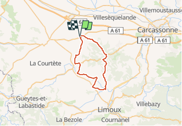

Length
40 km

Max alt
428 m

Uphill gradient
594 m
Km-Effort
48 km

Min alt
163 m

Downhill gradient
596 m
Boucle
Yes
Creation date :
2021-07-04 14:10:36.592
Updated on :
2021-07-04 14:10:58.851
2h53
Difficulty : Very difficult

FREE GPS app for hiking
 SityTrail
IGN / Geographical institutes
SityTrail Plus
The world is yours!
About
Trail Road bike of 40 km to be discovered at Occitania, Aude, Montréal. This trail is proposed by kodak.


Positioning
Country:
France
Region :
Occitania
Department/Province :
Aude
Municipality :
Montréal
Location:
Unknown
Start:(Dec)
Start:(UTM)
430077 ; 4783281 (31T) N.
Comments