


Vallée d'Argeles-Gazost

PhilippeC54
User
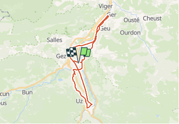

Length
30 km

Max alt
571 m

Uphill gradient
411 m
Km-Effort
36 km

Min alt
391 m

Downhill gradient
408 m
Boucle
Yes
Creation date :
2021-07-04 12:19:04.564
Updated on :
2021-07-04 14:20:08.538
1h43
Difficulty : Medium

FREE GPS app for hiking
 SityTrail
IGN / Geographical institutes
SityTrail Plus
The world is yours!
About
Trail Road bike of 30 km to be discovered at Occitania, Hautespyrenees, Argelès-Gazost. This trail is proposed by PhilippeC54.
Positioning
Country:
France
Region :
Occitania
Department/Province :
Hautespyrenees
Municipality :
Argelès-Gazost
Location:
Unknown
Start:(Dec)
Start:(UTM)
737510 ; 4765453 (30T) N.
Comments