


Les Opies 16,5km

thonyc
User GUIDE
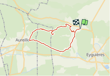

Length
15.1 km

Max alt
479 m

Uphill gradient
424 m
Km-Effort
21 km

Min alt
124 m

Downhill gradient
423 m
Boucle
Yes
Creation date :
2021-07-04 16:19:03.469
Updated on :
2021-07-17 18:17:48.576
4h49
Difficulty : Very difficult

FREE GPS app for hiking
 SityTrail
IGN / Geographical institutes
SityTrail Plus
The world is yours!
About
Trail Walking of 15.1 km to be discovered at Provence-Alpes-Côte d'Azur, Bouches-du-Rhône, Eyguières. This trail is proposed by thonyc.
Positioning
Country:
France
Region :
Provence-Alpes-Côte d'Azur
Department/Province :
Bouches-du-Rhône
Municipality :
Eyguières
Location:
Unknown
Start:(Dec)
Start:(UTM)
662141 ; 4842317 (31T) N.
Comments