


SityTrail - BDF Saint Cyr - St Didier

d.rognon
User
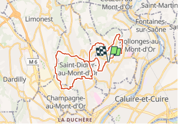

Length
16.7 km

Max alt
464 m

Uphill gradient
584 m
Km-Effort
24 km

Min alt
252 m

Downhill gradient
587 m
Boucle
Yes
Creation date :
2021-07-05 08:41:31.347
Updated on :
2021-09-21 17:39:15.461
5h33
Difficulty : Very difficult

FREE GPS app for hiking
 SityTrail
IGN / Geographical institutes
SityTrail Plus
The world is yours!
About
Trail Walking of 16.7 km to be discovered at Auvergne-Rhône-Alpes, Métropole de Lyon, Saint-Cyr-au-Mont-d'Or. This trail is proposed by d.rognon.
Description
Rando autour de Saint-Cyr et Saint-Didier au Mont D'Or
Positioning
Country:
France
Region :
Auvergne-Rhône-Alpes
Department/Province :
Métropole de Lyon
Municipality :
Saint-Cyr-au-Mont-d'Or
Location:
Unknown
Start:(Dec)
Start:(UTM)
641361 ; 5075059 (31T) N.
Comments