


Cirque de Gavarnie

PhilippeC54
User
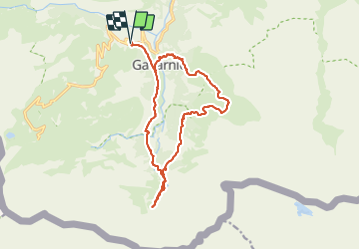

Length
17.2 km

Max alt
2046 m

Uphill gradient
1047 m
Km-Effort
31 km

Min alt
1373 m

Downhill gradient
1048 m
Boucle
Yes
Creation date :
2021-07-05 07:13:50.192
Updated on :
2021-07-05 14:29:22.892
5h34
Difficulty : Difficult

FREE GPS app for hiking
 SityTrail
IGN / Geographical institutes
SityTrail Plus
The world is yours!
About
Trail Walking of 17.2 km to be discovered at Occitania, Hautespyrenees, Gavarnie-Gèdre. This trail is proposed by PhilippeC54.
Positioning
Country:
France
Region :
Occitania
Department/Province :
Hautespyrenees
Municipality :
Gavarnie-Gèdre
Location:
Gavarnie
Start:(Dec)
Start:(UTM)
744001 ; 4736019 (30T) N.
Comments