


Lagorce - chapelle d’Adjude

algecko
User
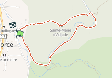

Length
2.6 km

Max alt
234 m

Uphill gradient
92 m
Km-Effort
3.8 km

Min alt
143 m

Downhill gradient
86 m
Boucle
Yes
Creation date :
2021-07-06 14:13:20.0
Updated on :
2021-07-06 14:58:56.698
45m
Difficulty : Easy

FREE GPS app for hiking
 SityTrail
IGN / Geographical institutes
SityTrail Plus
The world is yours!
About
Trail Walking of 2.6 km to be discovered at Auvergne-Rhône-Alpes, Ardèche, Lagorce. This trail is proposed by algecko.
Positioning
Country:
France
Region :
Auvergne-Rhône-Alpes
Department/Province :
Ardèche
Municipality :
Lagorce
Location:
Unknown
Start:(Dec)
Start:(UTM)
612941 ; 4922658 (31T) N.
Comments