


Corunum reconnaissance 2

fxhedon
User
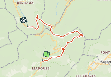

Length
14.2 km

Max alt
1650 m

Uphill gradient
747 m
Km-Effort
23 km

Min alt
997 m

Downhill gradient
476 m
Boucle
No
Creation date :
2021-07-05 12:22:24.0
Updated on :
2021-07-07 08:59:17.248
4h18
Difficulty : Very difficult

FREE GPS app for hiking
 SityTrail
IGN / Geographical institutes
SityTrail Plus
The world is yours!
About
Trail Walking of 14.2 km to be discovered at Auvergne-Rhône-Alpes, Cantal, Mandailles-Saint-Julien. This trail is proposed by fxhedon.
Description
Corunum reconnaissance. 2
Positioning
Country:
France
Region :
Auvergne-Rhône-Alpes
Department/Province :
Cantal
Municipality :
Mandailles-Saint-Julien
Location:
Unknown
Start:(Dec)
Start:(UTM)
474131 ; 4992269 (31T) N.
Comments