


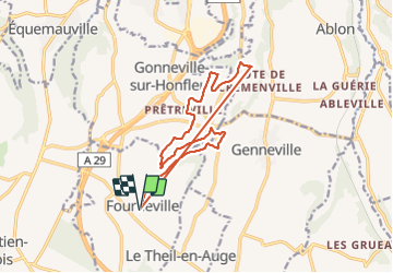
fourneville

semaine
User

Length
14.3 km

Max alt
123 m

Uphill gradient
283 m
Km-Effort
18.1 km

Min alt
30 m

Downhill gradient
285 m
Boucle
Yes
Creation date :
2021-07-08 06:47:02.645
Updated on :
2021-07-08 13:51:41.457
3h25
Difficulty : Difficult

FREE GPS app for hiking
 SityTrail
IGN / Geographical institutes
SityTrail Plus
The world is yours!
About
Trail Walking of 14.3 km to be discovered at Normandy, Calvados, Fourneville. This trail is proposed by semaine.
Positioning
Country:
France
Region :
Normandy
Department/Province :
Calvados
Municipality :
Fourneville
Location:
Unknown
Start:(Dec)
Start:(UTM)
299249 ; 5470806 (31U) N.
Comments