


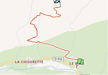
Le Tovet

whisper73
User

Length
3.9 km

Max alt
2152 m

Uphill gradient
692 m
Km-Effort
10.9 km

Min alt
1467 m

Downhill gradient
11 m
Boucle
No
Creation date :
2021-07-10 05:34:39.996
Updated on :
2021-07-10 14:20:13.095
1h58
Difficulty : Easy
15m
Difficulty : Easy

FREE GPS app for hiking
 SityTrail
IGN / Geographical institutes
SityTrail Plus
The world is yours!
About
Trail Walking of 3.9 km to be discovered at Auvergne-Rhône-Alpes, Savoy, Champagny-en-Vanoise. This trail is proposed by whisper73.
Positioning
Country:
France
Region :
Auvergne-Rhône-Alpes
Department/Province :
Savoy
Municipality :
Champagny-en-Vanoise
Location:
Unknown
Start:(Dec)
Start:(UTM)
323635 ; 5036407 (32T) N.
Comments