


Pointe de l’Adre Grand Port

michel.pegaz
User

Length
6.1 km

Max alt
291 m

Uphill gradient
74 m
Km-Effort
7.1 km

Min alt
230 m

Downhill gradient
69 m
Boucle
Yes
Creation date :
2021-07-11 07:28:00.0
Updated on :
2021-07-11 08:57:25.848
1h27
Difficulty : Easy

FREE GPS app for hiking
 SityTrail
IGN / Geographical institutes
SityTrail Plus
The world is yours!
About
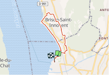
Trail Walking of 6.1 km to be discovered at Auvergne-Rhône-Alpes, Savoy, Aix-les-Bains. This trail is proposed by michel.pegaz.
Positioning
Country:
France
Region :
Auvergne-Rhône-Alpes
Department/Province :
Savoy
Municipality :
Aix-les-Bains
Location:
Unknown
Start:(Dec)
Start:(UTM)
724760 ; 5065463 (31T) N.
Comments