


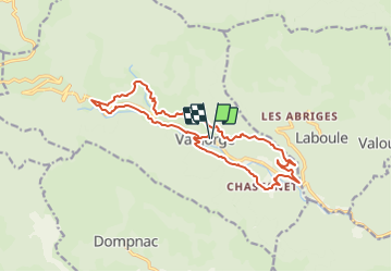
tour de valgorge

raab
User

Length
17.1 km

Max alt
825 m

Uphill gradient
597 m
Km-Effort
25 km

Min alt
433 m

Downhill gradient
598 m
Boucle
Yes
Creation date :
2021-07-11 09:42:24.371
Updated on :
2021-07-11 09:48:47.071
5h41
Difficulty : Medium

FREE GPS app for hiking
 SityTrail
IGN / Geographical institutes
SityTrail Plus
The world is yours!
About
Trail On foot of 17.1 km to be discovered at Auvergne-Rhône-Alpes, Ardèche, Valgorge. This trail is proposed by raab.
Positioning
Country:
France
Region :
Auvergne-Rhône-Alpes
Department/Province :
Ardèche
Municipality :
Valgorge
Location:
Unknown
Start:(Dec)
Start:(UTM)
589717 ; 4937747 (31T) N.
Comments