


reconnaissance Aisne amont Ste Menehould

DaVinci
User
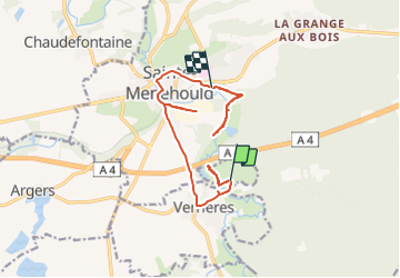

Length
13.3 km

Max alt
172 m

Uphill gradient
120 m
Km-Effort
14.9 km

Min alt
134 m

Downhill gradient
117 m
Boucle
No
Creation date :
2021-07-11 09:27:48.644
Updated on :
2021-07-11 10:39:27.326
1h11
Difficulty : Very easy

FREE GPS app for hiking
 SityTrail
IGN / Geographical institutes
SityTrail Plus
The world is yours!
About
Trail Canoe - kayak of 13.3 km to be discovered at Grand Est, Marne, Verrières. This trail is proposed by DaVinci.
Positioning
Country:
France
Region :
Grand Est
Department/Province :
Marne
Municipality :
Verrières
Location:
Unknown
Start:(Dec)
Start:(UTM)
639928 ; 5437055 (31U) N.
Comments