


baillet en france

Djaie60
User
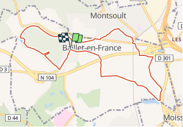

Length
10.4 km

Max alt
128 m

Uphill gradient
95 m
Km-Effort
11.7 km

Min alt
83 m

Downhill gradient
95 m
Boucle
Yes
Creation date :
2021-07-11 12:37:20.0
Updated on :
2021-10-03 17:42:14.137
2h38
Difficulty : Easy

FREE GPS app for hiking
 SityTrail
IGN / Geographical institutes
SityTrail Plus
The world is yours!
About
Trail On foot of 10.4 km to be discovered at Ile-de-France, Val-d'Oise, Baillet-en-France. This trail is proposed by Djaie60.
Positioning
Country:
France
Region :
Ile-de-France
Department/Province :
Val-d'Oise
Municipality :
Baillet-en-France
Location:
Unknown
Start:(Dec)
Start:(UTM)
448813 ; 5434685 (31U) N.
Comments