


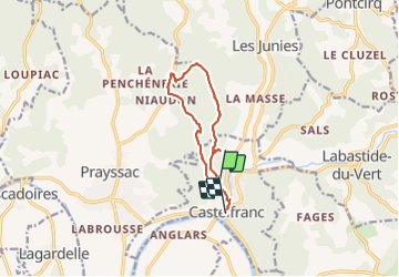
Castelfranc tour des dolmens

CABERMAT
User

Length
10.3 km

Max alt
286 m

Uphill gradient
236 m
Km-Effort
13.8 km

Min alt
95 m

Downhill gradient
351 m
Boucle
No
Creation date :
2021-07-11 09:15:40.467
Updated on :
2021-07-11 13:30:15.346
4h13
Difficulty : Difficult

FREE GPS app for hiking
 SityTrail
IGN / Geographical institutes
SityTrail Plus
The world is yours!
About
Trail Walking of 10.3 km to be discovered at Occitania, Lot, Castelfranc. This trail is proposed by CABERMAT.
Positioning
Country:
France
Region :
Occitania
Department/Province :
Lot
Municipality :
Castelfranc
Location:
Unknown
Start:(Dec)
Start:(UTM)
358574 ; 4929696 (31T) N.
Comments