![](/images/other/stat-length.png)
![Trail Walking Saint-Cyr-sur-le-Rhône - Sainte Baume 1er tronçon :St Cyr/Rhône-Vienne-Andancette - Photo](https://media.geolcdn.com/t/1900/400/ext.pjpeg?maxdim=2&url=https%3A%2F%2Fstatic1.geolcdn.com%2Fsiteimages%2Fupload%2Ffiles%2F1553511878bg_sport_marche.png)
Sainte Baume 1er tronçon :St Cyr/Rhône-Vienne-Andancette
FILLE
User
![Length](/images/other/stat-length.png)
Length
84 km
![Max alt](https://static1.geolcdn.com/siteimages/upload/files/1508320355ic_sort_altitude_max_24dp.png)
Max alt
325 m
![Uphill gradient](https://static1.geolcdn.com/siteimages/upload/files/1508320355ic_sort_den_pos_24dp.png)
Uphill gradient
934 m
![Km-Effort](/images/other/stat-length.png)
Km-Effort
97 km
![Min alt](https://static1.geolcdn.com/siteimages/upload/files/1508320355ic_sort_altitude_min_24dp.png)
Min alt
129 m
![Downhill gradient](https://static1.geolcdn.com/siteimages/upload/files/1508320355ic_sort_den_neg_24dp.png)
Downhill gradient
1089 m
![Boucle](https://static1.geolcdn.com/siteimages/upload/files/16400158638029165_repeat_loop_refresh_sync_direction_icon.png)
Boucle
No
Creation date :
2014-12-10 00:00:00.0
Updated on :
2014-12-10 00:00:00.0
![Walking](https://static1.geolcdn.com/sitytour/trail-icons/101.png)
5m
Difficulty : Unknown
![Scan this QR Code to open this trail in the SityTrail application](https://capi.geolives.com/qq0zvz2zws4bq2lad0pu/sitytour/trails/285725/qr.png?size=200)
FREE GPS app for hiking
About
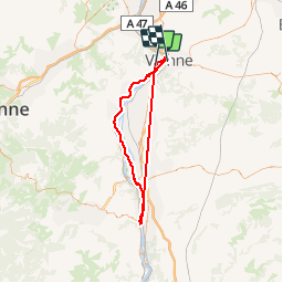
Trail Walking of 84 km to be discovered at Auvergne-Rhône-Alpes, Rhône, Saint-Cyr-sur-le-Rhône. This trail is proposed by FILLE.
Description
1er tronçon d'un nouveau parcours reliant Vienne (38) à La Sainte Baume (83).Depuis St Cyr/Rhône en passant par la cathédrale St Maurice à Vienne pour aller jusqu'à Andancette.
Positioning
Country:
France
Region :
Auvergne-Rhône-Alpes
Department/Province :
Rhône
Municipality :
Saint-Cyr-sur-le-Rhône
Location:
Unknown
Start:(Dec)
Start:(UTM)
643644 ; 5041779 (31T) N.
Comments
Trails nearby
![Trail Walking Saint-Romain-en-Gal - le grisard - Photo](https://media.geolcdn.com/t/375/260/ext.jpg?maxdim=2&url=https%3A%2F%2Fstatic1.geolcdn.com%2Fsiteimages%2Fupload%2Ffiles%2F1553511878bg_sport_marche.png)
![Walking Walking](https://static1.geolcdn.com/sitytour/trail-icons/101.png)
le grisard
Walking
Medium
(1)
Saint-Romain-en-Gal,
Auvergne-Rhône-Alpes,
Rhône,
France
![](/images/other/stat-length.png)
5.3 km | 7.9 km-effort
1h 48min
![](https://static1.geolcdn.com/siteimages/upload/files/16400158638029165_repeat_loop_refresh_sync_direction_icon.png)
Yes
![Trail Walking Loire-sur-Rhône - 69-loire-sur-rhone2-pet-de-loup-18km-560m - Photo](https://media.geolcdn.com/t/375/260/ext.jpg?maxdim=2&url=https%3A%2F%2Fmedia.geolcdn.com%2Ff%2Fee6f14b8-8ed9-4a30-84a4-6a7d5babc72f.jpg)
![Walking Walking](https://static1.geolcdn.com/sitytour/trail-icons/101.png)
69-loire-sur-rhone2-pet-de-loup-18km-560m
Walking
Medium
(1)
Loire-sur-Rhône,
Auvergne-Rhône-Alpes,
Rhône,
France
![](/images/other/stat-length.png)
17.7 km | 25 km-effort
3h 3min
![](https://static1.geolcdn.com/siteimages/upload/files/16400158638029165_repeat_loop_refresh_sync_direction_icon.png)
Yes
![Trail Hybrid bike Vienne - ViaRhona Vienne Coux 150km - Photo](https://media.geolcdn.com/t/375/260/ext.jpg?maxdim=2&url=https%3A%2F%2Fmedia.geolcdn.com%2Ff%2F10a23206-8a91-4410-b29f-f09d3d6a57f5.jpg)
![Hybrid bike Hybrid bike](https://static1.geolcdn.com/sitytour/trail-icons/203.png)
ViaRhona Vienne Coux 150km
Hybrid bike
Medium
Vienne,
Auvergne-Rhône-Alpes,
Isère,
France
![](/images/other/stat-length.png)
146 km | 162 km-effort
Unknown
![](https://static1.geolcdn.com/siteimages/upload/files/16400158638029165_repeat_loop_refresh_sync_direction_icon.png)
No
![Trail Walking Vienne - 38-Vienne-visite-4.5km-mai21 - Photo](https://media.geolcdn.com/t/375/260/ext.jpg?maxdim=2&url=https%3A%2F%2Fmedia.geolcdn.com%2Ff%2F15a6f21e-b5a5-4e05-9520-6ac715530426.jpg)
![Walking Walking](https://static1.geolcdn.com/sitytour/trail-icons/101.png)
38-Vienne-visite-4.5km-mai21
Walking
Easy
Vienne,
Auvergne-Rhône-Alpes,
Isère,
France
![](/images/other/stat-length.png)
4.6 km | 5.2 km-effort
1h 47min
![](https://static1.geolcdn.com/siteimages/upload/files/16400158638029165_repeat_loop_refresh_sync_direction_icon.png)
Yes
![Trail Walking Ampuis - AMPUIS JC - Photo](https://media.geolcdn.com/t/375/260/ext.jpg?maxdim=2&url=https%3A%2F%2Fstatic1.geolcdn.com%2Fsiteimages%2Fupload%2Ffiles%2F1553511878bg_sport_marche.png)
![Walking Walking](https://static1.geolcdn.com/sitytour/trail-icons/101.png)
AMPUIS JC
Walking
Very easy
(1)
Ampuis,
Auvergne-Rhône-Alpes,
Rhône,
France
![](/images/other/stat-length.png)
9.7 km | 12.1 km-effort
3h 10min
![](https://static1.geolcdn.com/siteimages/upload/files/16400158638029165_repeat_loop_refresh_sync_direction_icon.png)
Yes
![Trail Mountain bike Reventin-Vaugris - Écureuil 2013 - Photo](https://media.geolcdn.com/t/375/260/ext.jpg?maxdim=2&url=https%3A%2F%2Fstatic1.geolcdn.com%2Fsiteimages%2Fupload%2Ffiles%2F1524743154velo.jpg)
![Mountain bike Mountain bike](https://static1.geolcdn.com/sitytour/trail-icons/202.png)
Écureuil 2013
Mountain bike
Difficult
(1)
Reventin-Vaugris,
Auvergne-Rhône-Alpes,
Isère,
France
![](/images/other/stat-length.png)
30 km | 40 km-effort
2h 34min
![](https://static1.geolcdn.com/siteimages/upload/files/16400158638029165_repeat_loop_refresh_sync_direction_icon.png)
Yes
![Trail Cycle Vienne - Via Rhona : Vienne St Rambert d'Albon - Photo](https://media.geolcdn.com/t/375/260/ext.jpg?maxdim=2&url=https%3A%2F%2Fstatic1.geolcdn.com%2Fsiteimages%2Fupload%2Ffiles%2F1524743154velo.jpg)
![Cycle Cycle](https://static1.geolcdn.com/sitytour/trail-icons/200.png)
Via Rhona : Vienne St Rambert d'Albon
Cycle
Very easy
(1)
Vienne,
Auvergne-Rhône-Alpes,
Isère,
France
![](/images/other/stat-length.png)
36 km | 39 km-effort
Unknown
![](https://static1.geolcdn.com/siteimages/upload/files/16400158638029165_repeat_loop_refresh_sync_direction_icon.png)
No
![Trail Walking Vienne - 2023-10-08 - St Alban les Vignes - La Balme - Les Barres - Photo](https://media.geolcdn.com/t/375/260/ext.jpg?maxdim=2&url=https%3A%2F%2Fmedia.geolcdn.com%2Ff%2F0b9277b6-2ded-4d19-a426-204d6aa7e481.jpg)
![Walking Walking](https://static1.geolcdn.com/sitytour/trail-icons/101.png)
2023-10-08 - St Alban les Vignes - La Balme - Les Barres
Walking
Easy
Vienne,
Auvergne-Rhône-Alpes,
Isère,
France
![](/images/other/stat-length.png)
16.4 km | 24 km-effort
4h 53min
![](https://static1.geolcdn.com/siteimages/upload/files/16400158638029165_repeat_loop_refresh_sync_direction_icon.png)
Yes
![Trail Walking Vienne - naïade nocturne digestive à Vienne - Isère - Photo](https://media.geolcdn.com/t/375/260/ext.jpg?maxdim=2&url=https%3A%2F%2Fmedia.geolcdn.com%2Ff%2F3e0ddf70-00b3-4de3-8743-20a20b07d4cf.jpg)
![Walking Walking](https://static1.geolcdn.com/sitytour/trail-icons/101.png)
naïade nocturne digestive à Vienne - Isère
Walking
Very easy
Vienne,
Auvergne-Rhône-Alpes,
Isère,
France
![](/images/other/stat-length.png)
3 km | 3.6 km-effort
1h 38min
![](https://static1.geolcdn.com/siteimages/upload/files/16400158638029165_repeat_loop_refresh_sync_direction_icon.png)
Yes