


Robin

raygautier
User

Length
23 km

Max alt
1616 m

Uphill gradient
1048 m
Km-Effort
37 km

Min alt
895 m

Downhill gradient
1047 m
Boucle
Yes
Creation date :
2021-07-11 07:13:04.0
Updated on :
2021-07-11 19:49:18.814
7h32
Difficulty : Very difficult

FREE GPS app for hiking
 SityTrail
IGN / Geographical institutes
SityTrail Plus
The world is yours!
About
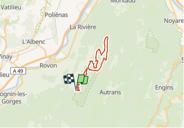
Trail Walking of 23 km to be discovered at Auvergne-Rhône-Alpes, Isère, Saint-Gervais. This trail is proposed by raygautier.
Positioning
Country:
France
Region :
Auvergne-Rhône-Alpes
Department/Province :
Isère
Municipality :
Saint-Gervais
Location:
Unknown
Start:(Dec)
Start:(UTM)
696315 ; 5005649 (31T) N.
Comments