


ITI0123

jeanic63
User
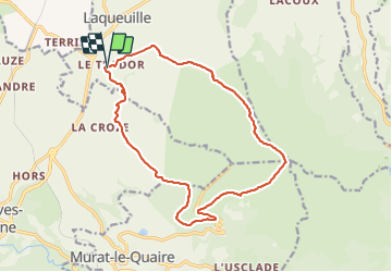

Length
16.8 km

Max alt
1476 m

Uphill gradient
610 m
Km-Effort
25 km

Min alt
944 m

Downhill gradient
604 m
Boucle
Yes
Creation date :
2021-07-13 07:47:13.207
Updated on :
2021-07-13 08:16:36.698
5h39
Difficulty : Medium

FREE GPS app for hiking
 SityTrail
IGN / Geographical institutes
SityTrail Plus
The world is yours!
About
Trail On foot of 16.8 km to be discovered at Auvergne-Rhône-Alpes, Puy-de-Dôme, Laqueuille. This trail is proposed by jeanic63.
Description
Départ : village de Trador, 700 m après Laqueille
Positioning
Country:
France
Region :
Auvergne-Rhône-Alpes
Department/Province :
Puy-de-Dôme
Municipality :
Laqueuille
Location:
Unknown
Start:(Dec)
Start:(UTM)
478901 ; 5054035 (31T) N.
Comments