


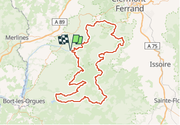
La bourboule - la bourboule gr 30 198 km

Melifera
User

Length
198 km

Max alt
1862 m

Uphill gradient
5892 m
Km-Effort
276 km

Min alt
689 m

Downhill gradient
5893 m
Boucle
Yes
Creation date :
2021-07-13 13:04:50.377
Updated on :
2021-09-04 18:32:45.591
70h00
Difficulty : Very difficult

FREE GPS app for hiking
 SityTrail
IGN / Geographical institutes
SityTrail Plus
The world is yours!
About
Trail Walking of 198 km to be discovered at Auvergne-Rhône-Alpes, Puy-de-Dôme, Murat-le-Quaire. This trail is proposed by Melifera.
Positioning
Country:
France
Region :
Auvergne-Rhône-Alpes
Department/Province :
Puy-de-Dôme
Municipality :
Murat-le-Quaire
Location:
Unknown
Start:(Dec)
Start:(UTM)
481021 ; 5048973 (31T) N.
Comments