


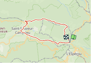
de la serre-tête à St sauveur de camprieu facile

labarone
User

Length
16.2 km

Max alt
1463 m

Uphill gradient
437 m
Km-Effort
22 km

Min alt
1095 m

Downhill gradient
435 m
Boucle
Yes
Creation date :
2021-07-13 07:56:07.283
Updated on :
2021-07-13 13:42:38.318
5h45
Difficulty : Medium

FREE GPS app for hiking
 SityTrail
IGN / Geographical institutes
SityTrail Plus
The world is yours!
About
Trail Walking of 16.2 km to be discovered at Occitania, Gard, Val-d'Aigoual. This trail is proposed by labarone.
Description
en juillet 7° puis bonne averse à camprieu
heureusement snack très correct pour s' abriter et manger
Positioning
Country:
France
Region :
Occitania
Department/Province :
Gard
Municipality :
Val-d'Aigoual
Location:
Valleraugue
Start:(Dec)
Start:(UTM)
543383 ; 4883475 (31T) N.
Comments
titre : de la Seyrerede à St Sauveur de Camprieu