


plainfaing auvernelles

Bob5757
User
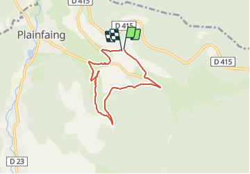

Length
5.8 km

Max alt
736 m

Uphill gradient
178 m
Km-Effort
8.2 km

Min alt
565 m

Downhill gradient
185 m
Boucle
Yes
Creation date :
2021-06-19 15:09:41.073
Updated on :
2021-07-13 15:47:27.778
1h44
Difficulty : Medium

FREE GPS app for hiking
 SityTrail
IGN / Geographical institutes
SityTrail Plus
The world is yours!
About
Trail Walking of 5.8 km to be discovered at Grand Est, Vosges, Plainfaing. This trail is proposed by Bob5757.
Photos


Positioning
Country:
France
Region :
Grand Est
Department/Province :
Vosges
Municipality :
Plainfaing
Location:
Unknown
Start:(Dec)
Start:(UTM)
353931 ; 5337104 (32U) N.
Comments