


bordeaux

panetJeanLuc
User
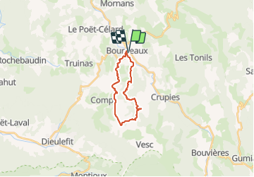

Length
19.2 km

Max alt
808 m

Uphill gradient
621 m
Km-Effort
27 km

Min alt
403 m

Downhill gradient
621 m
Boucle
Yes
Creation date :
2021-07-15 07:11:07.322
Updated on :
2021-07-15 17:39:05.032
4h56
Difficulty : Very difficult

FREE GPS app for hiking
 SityTrail
IGN / Geographical institutes
SityTrail Plus
The world is yours!
About
Trail Walking of 19.2 km to be discovered at Auvergne-Rhône-Alpes, Drôme, Bourdeaux. This trail is proposed by panetJeanLuc.
Positioning
Country:
France
Region :
Auvergne-Rhône-Alpes
Department/Province :
Drôme
Municipality :
Bourdeaux
Location:
Unknown
Start:(Dec)
Start:(UTM)
669561 ; 4939093 (31T) N.
Comments