


castel sarrazin

didier598
User
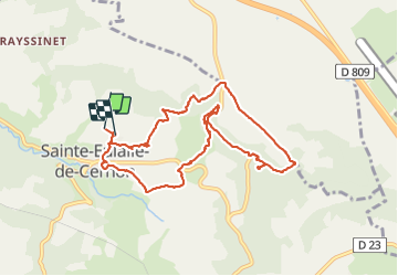

Length
9.9 km

Max alt
857 m

Uphill gradient
342 m
Km-Effort
14.5 km

Min alt
588 m

Downhill gradient
347 m
Boucle
Yes
Creation date :
2021-07-17 07:20:46.959
Updated on :
2021-07-17 10:45:50.37
2h30
Difficulty : Medium

FREE GPS app for hiking
 SityTrail
IGN / Geographical institutes
SityTrail Plus
The world is yours!
About
Trail Walking of 9.9 km to be discovered at Occitania, Aveyron, Sainte-Eulalie-de-Cernon. This trail is proposed by didier598.
Description
belle rando , ombragée, niveau moyen
Positioning
Country:
France
Region :
Occitania
Department/Province :
Aveyron
Municipality :
Sainte-Eulalie-de-Cernon
Location:
Unknown
Start:(Dec)
Start:(UTM)
510975 ; 4870282 (31T) N.
Comments