


2021-07-18_22h59m18_02-Lucelle-Abbaye Cistercienne

geranimo
User
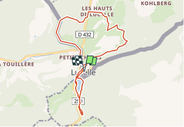

Length
9.2 km

Max alt
748 m

Uphill gradient
260 m
Km-Effort
12.6 km

Min alt
594 m

Downhill gradient
259 m
Boucle
Yes
Creation date :
2021-07-18 20:59:19.483
Updated on :
2021-07-25 22:31:13.087
2m
Difficulty : Medium

FREE GPS app for hiking
 SityTrail
IGN / Geographical institutes
SityTrail Plus
The world is yours!
About
Trail Walking of 9.2 km to be discovered at Grand Est, Haut-Rhin, Lucelle. This trail is proposed by geranimo.
Positioning
Country:
France
Region :
Grand Est
Department/Province :
Haut-Rhin
Municipality :
Lucelle
Location:
Unknown
Start:(Dec)
Start:(UTM)
367776 ; 5253500 (32T) N.
Comments