


C’enay

gegebe21
User
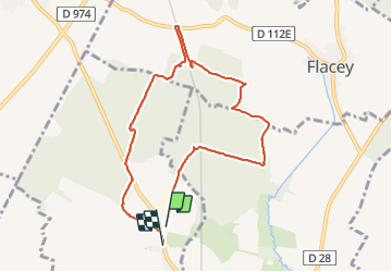

Length
8.4 km

Max alt
292 m

Uphill gradient
98 m
Km-Effort
9.7 km

Min alt
244 m

Downhill gradient
101 m
Boucle
No
Creation date :
2021-07-23 06:34:40.0
Updated on :
2021-07-23 08:47:04.025
2h11
Difficulty : Medium

FREE GPS app for hiking
 SityTrail
IGN / Geographical institutes
SityTrail Plus
The world is yours!
About
Trail Walking of 8.4 km to be discovered at Bourgogne-Franche-Comté, Côte-d'Or, Clénay. This trail is proposed by gegebe21.
Positioning
Country:
France
Region :
Bourgogne-Franche-Comté
Department/Province :
Côte-d'Or
Municipality :
Clénay
Location:
Unknown
Start:(Dec)
Start:(UTM)
660121 ; 5253135 (31T) N.
Comments