


Loungat - L'Uby

MarcLEBARON
User
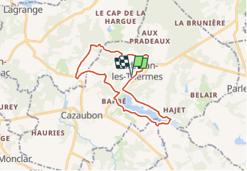

Length
15 km

Max alt
159 m

Uphill gradient
209 m
Km-Effort
17.8 km

Min alt
99 m

Downhill gradient
209 m
Boucle
Yes
Creation date :
2021-07-23 13:31:58.531
Updated on :
2021-07-23 16:46:18.989
3h05
Difficulty : Easy

FREE GPS app for hiking
 SityTrail
IGN / Geographical institutes
SityTrail Plus
The world is yours!
About
Trail Walking of 15 km to be discovered at Occitania, Gers, Cazaubon. This trail is proposed by MarcLEBARON.
Positioning
Country:
France
Region :
Occitania
Department/Province :
Gers
Municipality :
Cazaubon
Location:
Unknown
Start:(Dec)
Start:(UTM)
736974 ; 4870382 (30T) N.
Comments