


Col du Joly-Col de la fenêtre

nicolas54230
User
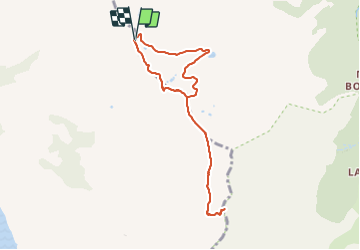

Length
7.9 km

Max alt
2242 m

Uphill gradient
348 m
Km-Effort
12.6 km

Min alt
1919 m

Downhill gradient
349 m
Boucle
Yes
Creation date :
2021-07-24 14:01:07.073
Updated on :
2021-07-24 14:02:02.241
2h51
Difficulty : Difficult

FREE GPS app for hiking
 SityTrail
IGN / Geographical institutes
SityTrail Plus
The world is yours!
About
Trail Walking of 7.9 km to be discovered at Auvergne-Rhône-Alpes, Savoy, Hauteluce. This trail is proposed by nicolas54230.
Positioning
Country:
France
Region :
Auvergne-Rhône-Alpes
Department/Province :
Savoy
Municipality :
Hauteluce
Location:
Unknown
Start:(Dec)
Start:(UTM)
319201 ; 5072672 (32T) N.
Comments