


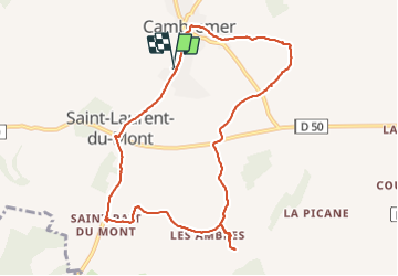
2021-07-24 Rando Cambremer

jchezlemas
User

Length
9.3 km

Max alt
151 m

Uphill gradient
157 m
Km-Effort
11.4 km

Min alt
72 m

Downhill gradient
159 m
Boucle
Yes
Creation date :
2021-07-24 12:39:39.104
Updated on :
2021-07-24 15:33:20.116
2h30
Difficulty : Easy

FREE GPS app for hiking
 SityTrail
IGN / Geographical institutes
SityTrail Plus
The world is yours!
About
Trail Walking of 9.3 km to be discovered at Normandy, Calvados, Cambremer. This trail is proposed by jchezlemas.
Positioning
Country:
France
Region :
Normandy
Department/Province :
Calvados
Municipality :
Cambremer
Location:
Cambremer
Start:(Dec)
Start:(UTM)
284551 ; 5448046 (31U) N.
Comments