


2021-07-25_01h12m25_04-Ferrette

geranimo
User
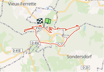

Length
8 km

Max alt
676 m

Uphill gradient
374 m
Km-Effort
13 km

Min alt
493 m

Downhill gradient
380 m
Boucle
Yes
Creation date :
2021-07-24 23:12:25.409
Updated on :
2021-07-28 23:03:18.471
4m
Difficulty : Medium

FREE GPS app for hiking
 SityTrail
IGN / Geographical institutes
SityTrail Plus
The world is yours!
About
Trail Walking of 8 km to be discovered at Grand Est, Haut-Rhin, Ferrette. This trail is proposed by geranimo.
Positioning
Country:
France
Region :
Grand Est
Department/Province :
Haut-Rhin
Municipality :
Ferrette
Location:
Unknown
Start:(Dec)
Start:(UTM)
373043 ; 5261494 (32T) N.
Comments