


ucps vienne en val

lemuid
User
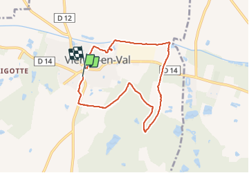

Length
7.2 km

Max alt
138 m

Uphill gradient
68 m
Km-Effort
8.2 km

Min alt
99 m

Downhill gradient
70 m
Boucle
Yes
Creation date :
2021-07-25 08:36:06.149
Updated on :
2021-07-25 11:23:35.055
1h36
Difficulty : Very easy

FREE GPS app for hiking
 SityTrail
IGN / Geographical institutes
SityTrail Plus
The world is yours!
About
Trail Walking of 7.2 km to be discovered at Centre-Loire Valley, Loiret, Vienne-en-Val. This trail is proposed by lemuid.
Positioning
Country:
France
Region :
Centre-Loire Valley
Department/Province :
Loiret
Municipality :
Vienne-en-Val
Location:
Unknown
Start:(Dec)
Start:(UTM)
435233 ; 5294379 (31T) N.
Comments