


Autour du gîte de tallans

carolineF11
User
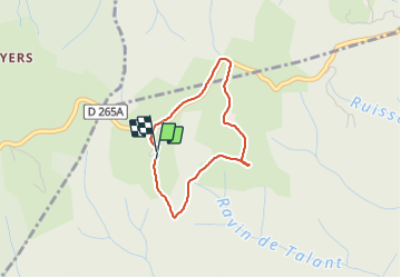

Length
2.7 km

Max alt
498 m

Uphill gradient
66 m
Km-Effort
3.6 km

Min alt
433 m

Downhill gradient
57 m
Boucle
Yes
Creation date :
2021-07-25 15:38:40.0
Updated on :
2021-07-25 16:25:57.365
45m
Difficulty : Easy

FREE GPS app for hiking
 SityTrail
IGN / Geographical institutes
SityTrail Plus
The world is yours!
About
Trail Walking of 2.7 km to be discovered at Auvergne-Rhône-Alpes, Ardèche, Rompon. This trail is proposed by carolineF11.
Positioning
Country:
France
Region :
Auvergne-Rhône-Alpes
Department/Province :
Ardèche
Municipality :
Rompon
Location:
Unknown
Start:(Dec)
Start:(UTM)
635715 ; 4961613 (31T) N.
Comments