


2021-07-26_00h19m25_07-Thann-Dentelle de pierre

geranimo
User
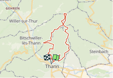

Length
15.3 km

Max alt
917 m

Uphill gradient
675 m
Km-Effort
24 km

Min alt
336 m

Downhill gradient
675 m
Boucle
Yes
Creation date :
2021-07-25 22:19:25.353
Updated on :
2021-07-29 18:26:04.107
7m
Difficulty : Medium

FREE GPS app for hiking
 SityTrail
IGN / Geographical institutes
SityTrail Plus
The world is yours!
About
Trail Walking of 15.3 km to be discovered at Grand Est, Haut-Rhin, Thann. This trail is proposed by geranimo.
Positioning
Country:
France
Region :
Grand Est
Department/Province :
Haut-Rhin
Municipality :
Thann
Location:
Unknown
Start:(Dec)
Start:(UTM)
357874 ; 5297080 (32T) N.
Comments