


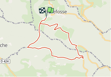
2021-07-28_00h47m21_24-Bellefosse

geranimo
User

Length
7.8 km

Max alt
922 m

Uphill gradient
292 m
Km-Effort
11.7 km

Min alt
682 m

Downhill gradient
291 m
Boucle
Yes
Creation date :
2021-07-27 22:47:21.886
Updated on :
2021-07-27 22:48:43.311
24m
Difficulty : Medium

FREE GPS app for hiking
 SityTrail
IGN / Geographical institutes
SityTrail Plus
The world is yours!
About
Trail Walking of 7.8 km to be discovered at Grand Est, Bas-Rhin, Bellefosse. This trail is proposed by geranimo.
Positioning
Country:
France
Region :
Grand Est
Department/Province :
Bas-Rhin
Municipality :
Bellefosse
Location:
Unknown
Start:(Dec)
Start:(UTM)
367694 ; 5362288 (32U) N.
Comments