


Rado France bleu

arnoultjf
User
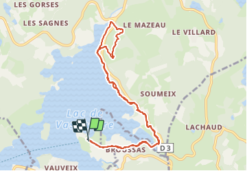

Length
10.6 km

Max alt
704 m

Uphill gradient
151 m
Km-Effort
12.6 km

Min alt
648 m

Downhill gradient
149 m
Boucle
Yes
Creation date :
2021-07-29 07:15:38.179
Updated on :
2021-07-29 10:36:17.435
3h10
Difficulty : Difficult

FREE GPS app for hiking
 SityTrail
IGN / Geographical institutes
SityTrail Plus
The world is yours!
About
Trail Walking of 10.6 km to be discovered at New Aquitaine, Creuse, Royère-de-Vassivière. This trail is proposed by arnoultjf.
Description
Moyenne
Positioning
Country:
France
Region :
New Aquitaine
Department/Province :
Creuse
Municipality :
Royère-de-Vassivière
Location:
Unknown
Start:(Dec)
Start:(UTM)
414603 ; 5071795 (31T) N.
Comments