


Orcieres. Ancelle

phil21
User
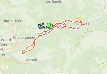

Length
41 km

Max alt
1571 m

Uphill gradient
1354 m
Km-Effort
59 km

Min alt
1123 m

Downhill gradient
1354 m
Boucle
Yes
Creation date :
2021-07-29 07:29:50.434
Updated on :
2021-07-29 11:41:01.126
3h59
Difficulty : Difficult

FREE GPS app for hiking
 SityTrail
IGN / Geographical institutes
SityTrail Plus
The world is yours!
About
Trail Mountain bike of 41 km to be discovered at Provence-Alpes-Côte d'Azur, Hautes-Alpes, Saint-Jean-Saint-Nicolas. This trail is proposed by phil21.
Positioning
Country:
France
Region :
Provence-Alpes-Côte d'Azur
Department/Province :
Hautes-Alpes
Municipality :
Saint-Jean-Saint-Nicolas
Location:
Unknown
Start:(Dec)
Start:(UTM)
281348 ; 4949922 (32T) N.
Comments