


Pr1 Molieres

Glurps
User
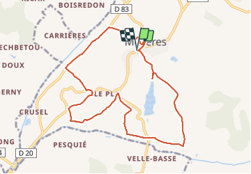

Length
10.2 km

Max alt
186 m

Uphill gradient
276 m
Km-Effort
13.8 km

Min alt
106 m

Downhill gradient
276 m
Boucle
Yes
Creation date :
2021-07-29 14:41:04.0
Updated on :
2021-07-29 17:24:41.163
2h42
Difficulty : Difficult

FREE GPS app for hiking
 SityTrail
IGN / Geographical institutes
SityTrail Plus
The world is yours!
About
Trail Walking of 10.2 km to be discovered at Occitania, Tarn-et-Garonne, Molières. This trail is proposed by Glurps.
Positioning
Country:
France
Region :
Occitania
Department/Province :
Tarn-et-Garonne
Municipality :
Molières
Location:
Unknown
Start:(Dec)
Start:(UTM)
369090 ; 4894571 (31T) N.
Comments