


Parcieux anse saint bernard trévoux

luccho
User
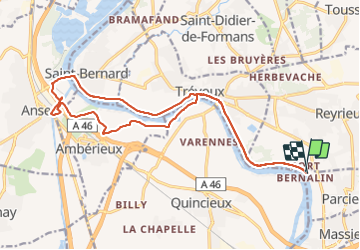

Length
19.6 km

Max alt
188 m

Uphill gradient
162 m
Km-Effort
22 km

Min alt
165 m

Downhill gradient
162 m
Boucle
Yes
Creation date :
2021-07-31 12:37:20.0
Updated on :
2021-07-31 17:04:33.76
3h42
Difficulty : Easy

FREE GPS app for hiking
 SityTrail
IGN / Geographical institutes
SityTrail Plus
The world is yours!
About
Trail Walking of 19.6 km to be discovered at Auvergne-Rhône-Alpes, Ain, Parcieux. This trail is proposed by luccho.
Positioning
Country:
France
Region :
Auvergne-Rhône-Alpes
Department/Province :
Ain
Municipality :
Parcieux
Location:
Unknown
Start:(Dec)
Start:(UTM)
640297 ; 5086952 (31T) N.
Comments