


col de la frasse

DaVinci
User
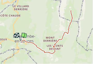

Length
10.2 km

Max alt
1385 m

Uphill gradient
558 m
Km-Effort
17.7 km

Min alt
822 m

Downhill gradient
558 m
Boucle
Yes
Creation date :
2021-08-01 12:39:48.043
Updated on :
2021-08-01 12:40:04.994
4h01
Difficulty : Difficult

FREE GPS app for hiking
 SityTrail
IGN / Geographical institutes
SityTrail Plus
The world is yours!
About
Trail Walking of 10.2 km to be discovered at Auvergne-Rhône-Alpes, Savoy, Bellecombe-en-Bauges. This trail is proposed by DaVinci.
Positioning
Country:
France
Region :
Auvergne-Rhône-Alpes
Department/Province :
Savoy
Municipality :
Bellecombe-en-Bauges
Location:
Unknown
Start:(Dec)
Start:(UTM)
277490 ; 5068867 (32T) N.
Comments