


sankt blasien-toodmoos

benjaminvh
User
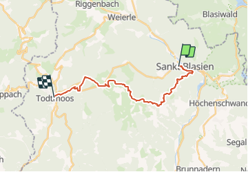

Length
18.9 km

Max alt
1136 m

Uphill gradient
628 m
Km-Effort
27 km

Min alt
773 m

Downhill gradient
622 m
Boucle
No
Creation date :
2021-08-01 12:54:58.889
Updated on :
2021-08-01 12:55:57.131
6h11
Difficulty : Very difficult

FREE GPS app for hiking
 SityTrail
IGN / Geographical institutes
SityTrail Plus
The world is yours!
About
Trail Walking of 18.9 km to be discovered at Baden-Württemberg, Landkreis Waldshut, St. Blasien. This trail is proposed by benjaminvh.
Description
2ieme etape foret noire
Positioning
Country:
Germany
Region :
Baden-Württemberg
Department/Province :
Landkreis Waldshut
Municipality :
St. Blasien
Location:
Unknown
Start:(Dec)
Start:(UTM)
434422 ; 5290040 (32T) N.
Comments