


Jarre

raygautier
User

Length
26 km

Max alt
757 m

Uphill gradient
880 m
Km-Effort
37 km

Min alt
320 m

Downhill gradient
722 m
Boucle
No
Creation date :
2021-08-01 07:08:48.0
Updated on :
2021-08-01 14:31:20.611
7h16
Difficulty : Very difficult

FREE GPS app for hiking
 SityTrail
IGN / Geographical institutes
SityTrail Plus
The world is yours!
About
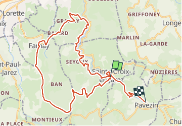
Trail Walking of 26 km to be discovered at Auvergne-Rhône-Alpes, Loire, Sainte-Croix-en-Jarez. This trail is proposed by raygautier.
Positioning
Country:
France
Region :
Auvergne-Rhône-Alpes
Department/Province :
Loire
Municipality :
Sainte-Croix-en-Jarez
Location:
Unknown
Start:(Dec)
Start:(UTM)
628677 ; 5037436 (31T) N.
Comments