


mezenc

Robertplessier
User
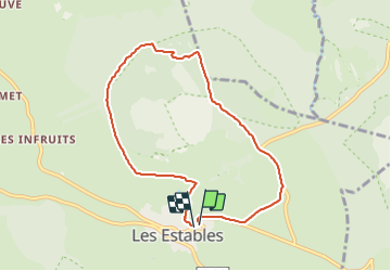

Length
7.7 km

Max alt
1588 m

Uphill gradient
235 m
Km-Effort
10.8 km

Min alt
1357 m

Downhill gradient
240 m
Boucle
Yes
Creation date :
2021-08-02 07:15:57.502
Updated on :
2021-08-02 08:05:56.907
49m
Difficulty : Very easy

FREE GPS app for hiking
 SityTrail
IGN / Geographical institutes
SityTrail Plus
The world is yours!
About
Trail Running of 7.7 km to be discovered at Auvergne-Rhône-Alpes, Haute-Loire, Les Estables. This trail is proposed by Robertplessier.
Positioning
Country:
France
Region :
Auvergne-Rhône-Alpes
Department/Province :
Haute-Loire
Municipality :
Les Estables
Location:
Unknown
Start:(Dec)
Start:(UTM)
591533 ; 4972997 (31T) N.
Comments