


Test 1

michel1025
User
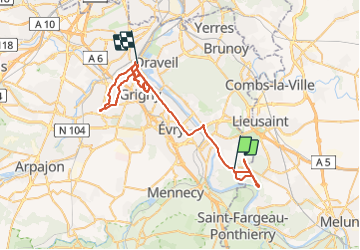

Length
67 km

Max alt
98 m

Uphill gradient
472 m
Km-Effort
73 km

Min alt
31 m

Downhill gradient
525 m
Boucle
No
Creation date :
2021-08-01 13:07:12.0
Updated on :
2021-08-03 11:03:00.496
43h37
Difficulty : Very difficult

FREE GPS app for hiking
 SityTrail
IGN / Geographical institutes
SityTrail Plus
The world is yours!
About
Trail Walking of 67 km to be discovered at Ile-de-France, Essonne, Saint-Pierre-du-Perray. This trail is proposed by michel1025.
Positioning
Country:
France
Region :
Ile-de-France
Department/Province :
Essonne
Municipality :
Saint-Pierre-du-Perray
Location:
Unknown
Start:(Dec)
Start:(UTM)
464360 ; 5381833 (31U) N.
Comments