


Lamothe capdeville Aussac

Glurps
User
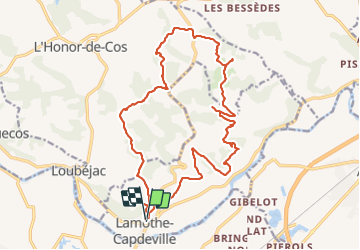

Length
22 km

Max alt
201 m

Uphill gradient
571 m
Km-Effort
29 km

Min alt
96 m

Downhill gradient
571 m
Boucle
Yes
Creation date :
2021-08-03 10:25:04.0
Updated on :
2021-08-03 16:49:10.686
5h57
Difficulty : Very difficult

FREE GPS app for hiking
 SityTrail
IGN / Geographical institutes
SityTrail Plus
The world is yours!
About
Trail Walking of 22 km to be discovered at Occitania, Tarn-et-Garonne, Lamothe-Capdeville. This trail is proposed by Glurps.
Positioning
Country:
France
Region :
Occitania
Department/Province :
Tarn-et-Garonne
Municipality :
Lamothe-Capdeville
Location:
Unknown
Start:(Dec)
Start:(UTM)
369620 ; 4881863 (31T) N.
Comments