


Abbaye d'Aulnes

Yves Lauwers
User
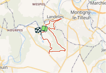

Length
11.4 km

Max alt
213 m

Uphill gradient
234 m
Km-Effort
14.4 km

Min alt
111 m

Downhill gradient
220 m
Boucle
Yes
Creation date :
2021-07-25 07:34:08.207
Updated on :
2021-08-04 07:40:20.915
2h26
Difficulty : Very easy

FREE GPS app for hiking
 SityTrail
IGN / Geographical institutes
SityTrail Plus
The world is yours!
About
Trail Nordic walking of 11.4 km to be discovered at Wallonia, Hainaut, Thuin. This trail is proposed by Yves Lauwers.
Positioning
Country:
Belgium
Region :
Wallonia
Department/Province :
Hainaut
Municipality :
Thuin
Location:
Unknown
Start:(Dec)
Start:(UTM)
594769 ; 5579942 (31U) N.
Comments