


Irouléguy

rollondesbois
User
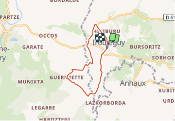

Length
5.8 km

Max alt
277 m

Uphill gradient
151 m
Km-Effort
7.8 km

Min alt
199 m

Downhill gradient
149 m
Boucle
Yes
Creation date :
2021-08-04 07:51:55.624
Updated on :
2021-08-04 07:53:10.861
1h46
Difficulty : Medium

FREE GPS app for hiking
 SityTrail
IGN / Geographical institutes
SityTrail Plus
The world is yours!
About
Trail Walking of 5.8 km to be discovered at New Aquitaine, Pyrénées-Atlantiques, Irouléguy. This trail is proposed by rollondesbois.
Positioning
Country:
France
Region :
New Aquitaine
Department/Province :
Pyrénées-Atlantiques
Municipality :
Irouléguy
Location:
Unknown
Start:(Dec)
Start:(UTM)
638155 ; 4781997 (30T) N.
Comments