


2021-08-05_11h13m16_t50557760_hunspach et la ligne

chlafaille
User
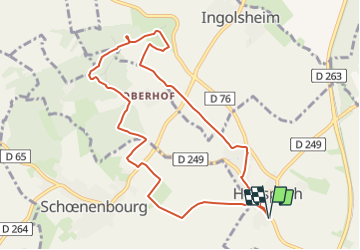

Length
9.3 km

Max alt
219 m

Uphill gradient
127 m
Km-Effort
11 km

Min alt
152 m

Downhill gradient
127 m
Boucle
Yes
Creation date :
2021-08-05 09:13:16.72
Updated on :
2021-08-05 09:13:18.789

FREE GPS app for hiking
 SityTrail
IGN / Geographical institutes
SityTrail Plus
The world is yours!
About
Trail of 9.3 km to be discovered at Grand Est, Bas-Rhin, Hunspach. This trail is proposed by chlafaille.
Positioning
Country:
France
Region :
Grand Est
Department/Province :
Bas-Rhin
Municipality :
Hunspach
Location:
Unknown
Start:(Dec)
Start:(UTM)
422528 ; 5422507 (32U) N.
Comments