


mais.fores.,,val de fer 6_-8-22
© OpenStreetMap contributors


2h30
Difficulty : Medium


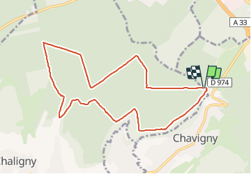
Length
9.5 km
Max alt
418 m
Uphill gradient
209 m
Km-Effort
12.3 km
Min alt
306 m
Downhill gradient
207 m
Boucle
Yes
Creation date :
2021-08-06 13:59:04.229
Updated on :
2021-08-06 17:19:14.405
2h30
Difficulty : Medium
FREE GPS app for hiking
 SityTrail
IGN / Geographical institutes
SityTrail Plus
The world is yours!
About
Trail Walking of 9.5 km to be discovered at Grand Est, Meurthe-et-Moselle, Chavigny. This trail is proposed by jerome-dupont@laposte.net.
Description
foret chemins facilrd
Positioning
Country:
France
Region :
Grand Est
Department/Province :
Meurthe-et-Moselle
Municipality :
Chavigny
Location:
Unknown
Start:(Dec)
Start:(UTM)
288350 ; 5391149 (32U) N.
Comments