


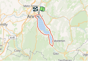
Tour du lac d’Annecy

domifon
User

Length
38 km

Max alt
557 m

Uphill gradient
466 m
Km-Effort
44 km

Min alt
446 m

Downhill gradient
467 m
Boucle
Yes
Creation date :
2021-08-08 12:39:28.0
Updated on :
2021-08-08 14:18:56.72
1h39
Difficulty : Easy

FREE GPS app for hiking
 SityTrail
IGN / Geographical institutes
SityTrail Plus
The world is yours!
About
Trail Mountain bike of 38 km to be discovered at Auvergne-Rhône-Alpes, Upper Savoy, Annecy. This trail is proposed by domifon.
Positioning
Country:
France
Region :
Auvergne-Rhône-Alpes
Department/Province :
Upper Savoy
Municipality :
Annecy
Location:
Annecy-le-Vieux
Start:(Dec)
Start:(UTM)
279080 ; 5087608 (32T) N.
Comments