


2021 08 BAGNOLS T1

michel1025
User
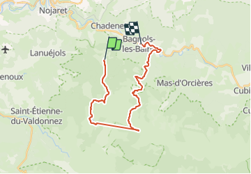

Length
24 km

Max alt
1560 m

Uphill gradient
560 m
Km-Effort
33 km

Min alt
910 m

Downhill gradient
836 m
Boucle
No
Creation date :
2021-08-09 07:21:36.0
Updated on :
2021-08-09 15:25:54.466
5h22
Difficulty : Very difficult

FREE GPS app for hiking
 SityTrail
IGN / Geographical institutes
SityTrail Plus
The world is yours!
About
Trail Walking of 24 km to be discovered at Occitania, Lozère, Lanuéjols. This trail is proposed by michel1025.
Positioning
Country:
France
Region :
Occitania
Department/Province :
Lozère
Municipality :
Lanuéjols
Location:
Unknown
Start:(Dec)
Start:(UTM)
550031 ; 4927128 (31T) N.
Comments