


Cipières plateau de Calerm Observatoire

luccho
User
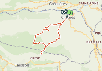

Length
15.3 km

Max alt
1269 m

Uphill gradient
547 m
Km-Effort
23 km

Min alt
751 m

Downhill gradient
583 m
Boucle
No
Creation date :
2021-08-08 08:32:00.0
Updated on :
2021-08-09 17:16:38.258
4h44
Difficulty : Easy

FREE GPS app for hiking
 SityTrail
IGN / Geographical institutes
SityTrail Plus
The world is yours!
About
Trail Walking of 15.3 km to be discovered at Provence-Alpes-Côte d'Azur, Maritime Alps, Cipières. This trail is proposed by luccho.
Positioning
Country:
France
Region :
Provence-Alpes-Côte d'Azur
Department/Province :
Maritime Alps
Municipality :
Cipières
Location:
Unknown
Start:(Dec)
Start:(UTM)
335350 ; 4849675 (32T) N.
Comments