


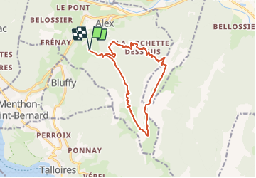
Talamarche par le Trou de la Chapelle

gregou74
User

Length
14.5 km

Max alt
1838 m

Uphill gradient
1313 m
Km-Effort
32 km

Min alt
727 m

Downhill gradient
1313 m
Boucle
Yes
Creation date :
2021-08-09 20:27:27.735
Updated on :
2021-08-09 20:28:45.315
7h16
Difficulty : Very difficult

FREE GPS app for hiking
 SityTrail
IGN / Geographical institutes
SityTrail Plus
The world is yours!
About
Trail Walking of 14.5 km to be discovered at Auvergne-Rhône-Alpes, Upper Savoy, Alex. This trail is proposed by gregou74.
Positioning
Country:
France
Region :
Auvergne-Rhône-Alpes
Department/Province :
Upper Savoy
Municipality :
Alex
Location:
Unknown
Start:(Dec)
Start:(UTM)
285093 ; 5084446 (32T) N.
Comments